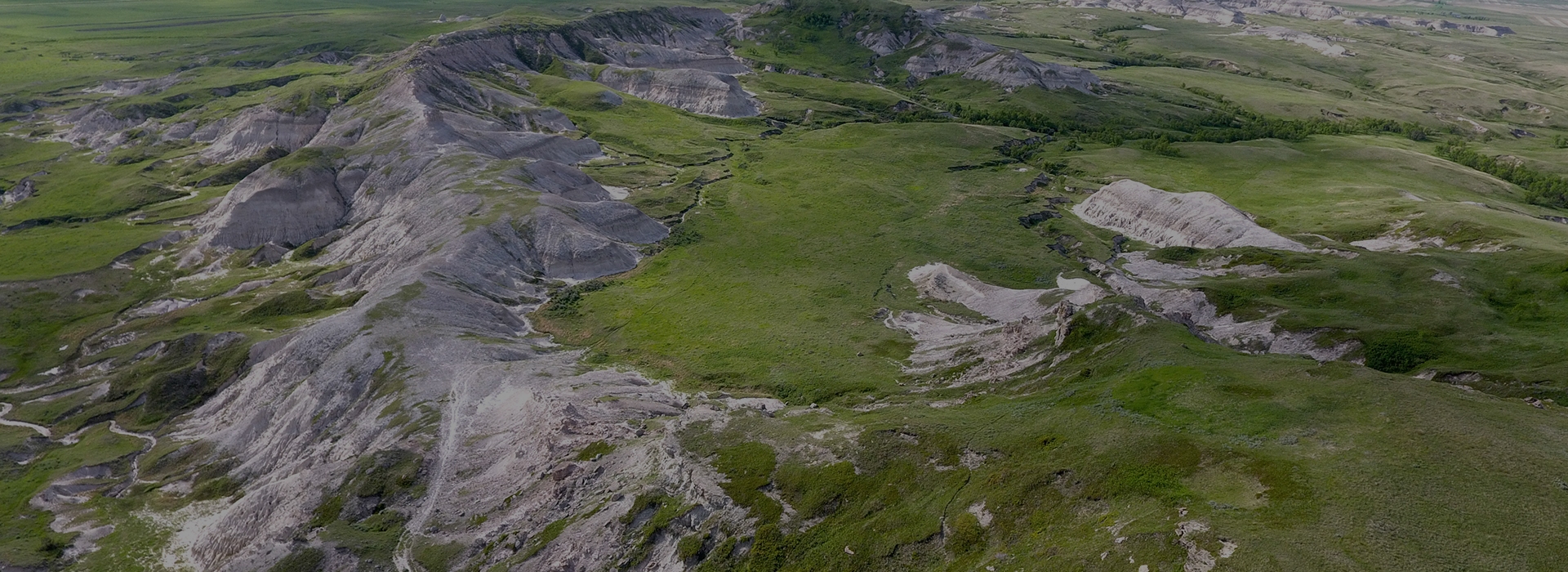
The Great Outdoors

White Butte

Located on Highway 85, north of Bowman, White Butte is North Dakota’s highest natural point at 3,506 feet overlooking the Little Missouri National Grassland. You can hike year round, but some of the best times are in the spring. Enjoy the beauty of the nearby scenery, native flowers and grass, and the stillness of nature. White Butte may not be the most strenuous hike you conquer, but it will definitely be one of the most memorable ones. The trail offers numerous activities and amazing photo opportunities. When you get to the top, don’t forget to sign the guest book and scan the QR Code! White Butte is surrounded by private land, so please be respectful.


Promotion

Scan the QR Code on the sign on top of White Butte to redeem a local coupon book and get a discount on a White Butte t-shirt.


Phone: 701-523-5880
Directions: 2 miles east of Amidon on Hwy 85, turn south and go 5 miles, turn west and go 1 mile

Printable Map

Official Easement Allows for Public Access without Permission

Maah Daah Hey Trail

The Maah Daah Hey trail is the longest single-track mountain biking route in the United States. This 144 mile trail unit showcases majestic plateaus, jagged peaks and valleys, large expanses of prairie, and rivers that can be enjoyed by biking, hiking, or horseback riding. There are 16 trailheads in total, one of which is located inside Burning Coal Vein Campground on the west of the campground. The Burning Coal Vein trailhead is located 15 miles west and north of Amidon and the trail travels north through the south and north units of Theodore Roosevelt National Park and the Little Missouri National Grassland.


Maah Daah Hey Trail

Printable Map

Upcoming Race Information

Burning Coal Vein

Burning Coal Vein is a badlands landscape still in the making. The fire smoldering in the coal layer several feet underground was burning when viewed by the first settlers in the area over a hundred years ago. Burning Coal Vein and is part of Little Missouri National Grassland’s natural area with adjoining campground.

The underground fire is no longer active, but local landscape features and columnar Rocky Mountain juniper (cedar) bear witness to the effects of the continuous smoke of past years.


Burning Coal Vein campground has 8 sites, each with it’s own picnic table and a fire ring with a grill. The campground also has a handicap accessible toilet and potable water from a well with a hand pump. It is a great place to start your adventure hiking or backpacking with its location being the southernmost trailhead to the Maah Daah Hey Trail.


Directions: 15 miles west and north of Amidon


Printable Map

Cave Hills

The Cave Hills are a pair of expansive buttes in far northwestern South Dakota capped in sandstone and covered in pine trees. The North and South Unit of the Cave Hills are divided by Bull Creek. The North Cave Hills are the most popular and were also home to uranium mines in the mid-1900s. To this day, reclamation efforts are still happening in the Cave Hills and making way for better road access for you to navigate the area with ease. The Cave Hills are part of Custer National Forest and are maintained by USDA Forest Service.


Whether you are looking for a short or long hike, a beautiful drive, a gorgeous hammocking location, or a weekend camping in beautiful scenery, the Cave Hills will not disappoint. Camping is available at the Picnic Spring Campground on a first-come, first-serve basis. There are 8 primitive sites with toilet access, non-potable water, and a 14 day limit. With enough research and searching you may find the hidden gem of the North Cave Hills, Ludlow Cave, which is known for its petroglyphs.


Approximately 40 miles south of Bowman


Road Map from USDA Forest Service

Printable Map

Additional Pictures

Dinosaur Capital of ND

The site contains 65-million-year-old dinosaur fossils, including triceratops and tyrannosaurus rex.


Phone: 701-279-6601
Phone: 610-937-7916
June 24 – Aug.18

Fort Dilts State Historic Site

On this site in 1864, a wagon train party under the command of Capt. James L. Fisk was besieged by Sioux Indians including Sitting Bull. The emigrants of the embattled wagon train circled their wagons and waited for rescue by the cavalry. At the site you will find an interpretive plaque, many of the features are still visible, including the sod wall, wagon ruts, graves, and an uncompleted well. Archaeological excavations confirm the site is essentially undisturbed. Learn more about the fate of the wagon train through the interpretive display at the Pioneer Trails Regional Museum.


Fort Dilts Historic Site

Printable Map
Phone: 701-523-3600

Yellowstone Trail

In 1912, a group of small town businessmen in South Dakota undertook an ambitious project to create a useful automobile route, the Yellowstone Trail, across America. The trail came through the southwest corner of North Dakota hitting Marmarth, Rhame, Bowman, Buffalo Springs, Scranton, Gascoyne, Reeder, Bucyrus, Hettinger, and Haynes.


Yellowstone Trail Information

Little Missouri National Grassland

Little Missouri National Grassland is the largest and most diverse of the 19 grasslands found in the western United States. At 1,028,051 acres it is the largest grassland in the country. A predominant feature of the grassland is colorful and beautiful badlands, a rugged terrain extensively eroded by wind and water.

Visitors can enjoy the abundant wildlife and a wide range of recreational opportunities. Watch for prairie dog towns, eagle and falcon nests, elk, antelope, mule deer and white-tailed deer. Resource use on the grasslands include paleontological and archeological digs, oil and gas production, cattle grazing, and recreation. Within its borders is Theodore Roosevelt National Park and White Butte, North Dakota’s highest point, is located in the extreme southeast corner of the grassland, south of the town of Amidon.


Dakota Prairie National Grassland

South Unit – Medora Ranger District
Phone: 701-227-7800
Hwy 85 N and S of Belfield

Stewart Lake National Wildlife Refuge

Stewart Lake in Slope County is approximately 8 miles southwest of Amidon, North Dakota. This 197 acre lake is surrounded by 2,033 acres of native grasslands, tame grasses, and rock outcroppings. Stewart Lake is the largest wetland on the refuge, and is the major water bird oasis in the area. Enjoy an easy 2-mile hike round trip to an old stone gazebo and overlook what was once a popular gathering place for picnicking, swimming, and fishing activities. Hunting and fishing is not allowed at the refuge.

President Franklin D. Roosevelt established Stewart Lake National Wildlife Refuge as a breeding ground for migratory birds and other wildlife in 1941.

National Wildlife Rescue Website

Contact

CONTACT

(701) 523-5880

13 1/2 E Divide
PO Box 1143

Bowman, ND 58623

brooklyn@bowmannd.com

OFFICE HOURS

Monday- Friday

8 am – 5 pm MT

Closed on legal holidays